


krappenfels_ 27 MARS 2015 11_07

apa
User
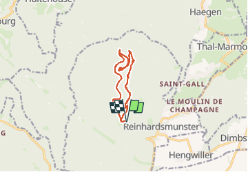

Length
10.9 km

Max alt
566 m

Uphill gradient
326 m
Km-Effort
15.2 km

Min alt
379 m

Downhill gradient
326 m
Boucle
Yes
Creation date :
2025-08-21 21:15:22.43
Updated on :
2025-08-21 21:15:22.43

FREE GPS app for hiking
 SityTrail
IGN / Geographical institutes
SityTrail Plus
The world is yours!
About
Trail of 10.9 km to be discovered at Grand Est, Bas-Rhin, Reinhardsmunster. This trail is proposed by apa.
Positioning
Country:
France
Region :
Grand Est
Department/Province :
Bas-Rhin
Municipality :
Reinhardsmunster
Location:
Unknown
Start:(Dec)
Start:(UTM)
374903 ; 5393060 (32U) N.
Comments