


doi suthep et village hmong

mapomme
User
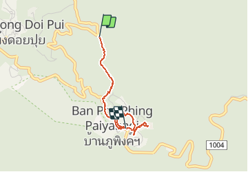

Length
4.1 km

Max alt
1583 m

Uphill gradient
73 m
Km-Effort
5.7 km

Min alt
1380 m

Downhill gradient
265 m
Boucle
No
Creation date :
2015-08-16 00:00:00.0
Updated on :
2015-08-16 00:00:00.0
1h16
Difficulty : Very easy

FREE GPS app for hiking
 SityTrail
IGN / Geographical institutes
SityTrail Plus
The world is yours!
About
Trail Other activity of 4.1 km to be discovered at Chiang Mai Province. This trail is proposed by mapomme.
Positioning
Country:
Thailand
Region :
Chiang Mai Province
Department/Province :
Unknown
Municipality :
Unknown
Location:
Unknown
Start:(Dec)
Start:(UTM)
488906 ; 2080431 (47Q) N.
Comments