


André M

andremusin
User
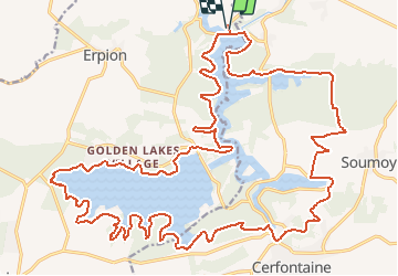

Length
33 km

Max alt
285 m

Uphill gradient
479 m
Km-Effort
39 km

Min alt
199 m

Downhill gradient
483 m
Boucle
Yes
Creation date :
2016-10-14 00:00:00.0
Updated on :
2016-10-14 00:00:00.0
8h28
Difficulty : Very easy

FREE GPS app for hiking
 SityTrail
IGN / Geographical institutes
SityTrail Plus
The world is yours!
About
Trail Walking of 33 km to be discovered at Wallonia, Hainaut, Froidchapelle. This trail is proposed by andremusin.
Description
Les lacs de l'Eau d'Heure
Positioning
Country:
Belgium
Region :
Wallonia
Department/Province :
Hainaut
Municipality :
Froidchapelle
Location:
Boussu-lez-Walcourt
Start:(Dec)
Start:(UTM)
599399 ; 5563621 (31U) N.
Comments