


Les Hauts Vernis

jmheydorff
User
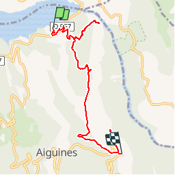

Length
7.5 km

Max alt
995 m

Uphill gradient
634 m
Km-Effort
14.3 km

Min alt
485 m

Downhill gradient
159 m
Boucle
No
Creation date :
2015-09-03 00:00:00.0
Updated on :
2015-09-03 00:00:00.0
3h47
Difficulty : Difficult

FREE GPS app for hiking
 SityTrail
IGN / Geographical institutes
SityTrail Plus
The world is yours!
About
Trail Walking of 7.5 km to be discovered at Provence-Alpes-Côte d'Azur, Var, Aiguines. This trail is proposed by jmheydorff.
Description
Faire un échange de voitures, entre le début et la fin de la rando: 8 kms 900m - 500m ou l'inverse 4h00
Positioning
Country:
France
Region :
Provence-Alpes-Côte d'Azur
Department/Province :
Var
Municipality :
Aiguines
Location:
Unknown
Start:(Dec)
Start:(UTM)
278183 ; 4853154 (32T) N.
Comments