


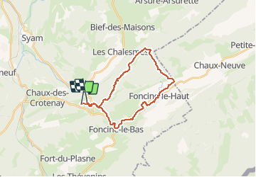
Gorges de la Langouette 24.5 km

cmike39
User

Length
24 km

Max alt
1194 m

Uphill gradient
653 m
Km-Effort
33 km

Min alt
692 m

Downhill gradient
649 m
Boucle
No
Creation date :
2016-10-06 00:00:00.0
Updated on :
2016-10-06 00:00:00.0
7h03
Difficulty : Unknown

FREE GPS app for hiking
 SityTrail
IGN / Geographical institutes
SityTrail Plus
The world is yours!
About
Trail Walking of 24 km to be discovered at Bourgogne-Franche-Comté, Jura, Les Planches-en-Montagne. This trail is proposed by cmike39.
Description
RSGD Daniel J.
Positioning
Country:
France
Region :
Bourgogne-Franche-Comté
Department/Province :
Jura
Municipality :
Les Planches-en-Montagne
Location:
Unknown
Start:(Dec)
Start:(UTM)
729469 ; 5171138 (31T) N.
Comments
facile