


Cascade d'Ars par le pas de l'enfer

DENOMME
User
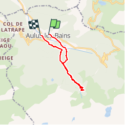

Length
11.3 km

Max alt
1467 m

Uphill gradient
711 m
Km-Effort
21 km

Min alt
739 m

Downhill gradient
731 m
Boucle
No
Creation date :
2015-08-19 00:00:00.0
Updated on :
2015-08-19 00:00:00.0
3h30
Difficulty : Medium

FREE GPS app for hiking
 SityTrail
IGN / Geographical institutes
SityTrail Plus
The world is yours!
About
Trail Walking of 11.3 km to be discovered at Occitania, Ariège, Aulus-les-Bains. This trail is proposed by DENOMME.
Positioning
Country:
France
Region :
Occitania
Department/Province :
Ariège
Municipality :
Aulus-les-Bains
Location:
Unknown
Start:(Dec)
Start:(UTM)
364212 ; 4738929 (31T) N.
Comments