Brunissard - Ref Furfande (simu ST)

motardes04
User

Length
10.8 km

Max alt
2497 m

Uphill gradient
931 m
Km-Effort
22 km

Min alt
1727 m

Downhill gradient
415 m
Boucle
No
Creation date :
2015-08-24 00:00:00.0
Updated on :
2015-08-24 00:00:00.0
4h43
Difficulty : Very easy

FREE GPS app for hiking
 SityTrail
IGN / Geographical institutes
SityTrail Plus
The world is yours!
About
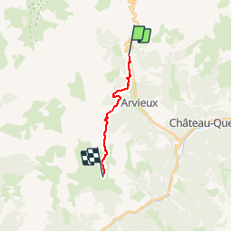
Trail Walking of 10.8 km to be discovered at Provence-Alpes-Côte d'Azur, Hautes-Alpes, Arvieux. This trail is proposed by motardes04.
Positioning
Country:
France
Region :
Provence-Alpes-Côte d'Azur
Department/Province :
Hautes-Alpes
Municipality :
Arvieux
Location:
Unknown
Start:(Dec)
Start:(UTM)
320554 ; 4962496 (32T) N.
Comments