


GR68 - 6

cron
User
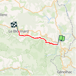

Length
23 km

Max alt
1196 m

Uphill gradient
993 m
Km-Effort
35 km

Min alt
633 m

Downhill gradient
558 m
Boucle
No
Creation date :
2017-03-05 00:00:00.0
Updated on :
2017-03-05 00:00:00.0
8h06
Difficulty : Medium

FREE GPS app for hiking
 SityTrail
IGN / Geographical institutes
SityTrail Plus
The world is yours!
About
Trail Walking of 23 km to be discovered at Occitania, Lozère, Villefort. This trail is proposed by cron.
Positioning
Country:
France
Region :
Occitania
Department/Province :
Lozère
Municipality :
Villefort
Location:
Unknown
Start:(Dec)
Start:(UTM)
573050 ; 4921248 (31T) N.
Comments