


Madières la Séranne

nanie
User
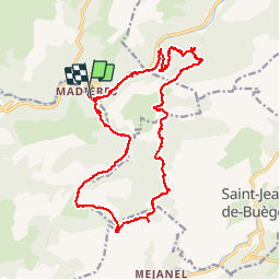

Length
21 km

Max alt
778 m

Uphill gradient
730 m
Km-Effort
30 km

Min alt
220 m

Downhill gradient
725 m
Boucle
Yes
Creation date :
2015-08-28 00:00:00.0
Updated on :
2025-04-15 17:23:35.695
6h53
Difficulty : Very difficult

FREE GPS app for hiking
 SityTrail
IGN / Geographical institutes
SityTrail Plus
The world is yours!
About
Trail Walking of 21 km to be discovered at Occitania, Hérault, Saint-Maurice-Navacelles. This trail is proposed by nanie.
Positioning
Country:
France
Region :
Occitania
Department/Province :
Hérault
Municipality :
Saint-Maurice-Navacelles
Location:
Unknown
Start:(Dec)
Start:(UTM)
545403 ; 4855699 (31T) N.
Comments