


chablis

olivieraron
User
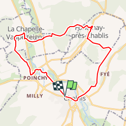

Length
16.6 km

Max alt
254 m

Uphill gradient
349 m
Km-Effort
21 km

Min alt
121 m

Downhill gradient
348 m
Boucle
Yes
Creation date :
2019-01-14 09:45:06.281
Updated on :
2019-01-14 09:45:07.741
7m
Difficulty : Unknown

FREE GPS app for hiking
 SityTrail
IGN / Geographical institutes
SityTrail Plus
The world is yours!
About
Trail Other activity of 16.6 km to be discovered at Bourgogne-Franche-Comté, Yonne, Chablis. This trail is proposed by olivieraron.
Positioning
Country:
France
Region :
Bourgogne-Franche-Comté
Department/Province :
Yonne
Municipality :
Chablis
Location:
Unknown
Start:(Dec)
Start:(UTM)
559409 ; 5296148 (31T) N.
Comments