


GR 129 : Solre-sur-Sambre > Landelies

jojolemarcheur
User
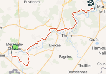

Length
26 km

Max alt
200 m

Uphill gradient
421 m
Km-Effort
31 km

Min alt
112 m

Downhill gradient
430 m
Boucle
No
Creation date :
2015-08-30 00:00:00.0
Updated on :
2015-08-30 00:00:00.0
6h44
Difficulty : Medium

FREE GPS app for hiking
 SityTrail
IGN / Geographical institutes
SityTrail Plus
The world is yours!
About
Trail Walking of 26 km to be discovered at Wallonia, Hainaut, Erquelinnes. This trail is proposed by jojolemarcheur.
Description
La Belgique en diagonale ! Tronçon Ellezelles > Dinant.Facile au début, puis moyen.
Positioning
Country:
Belgium
Region :
Wallonia
Department/Province :
Hainaut
Municipality :
Erquelinnes
Location:
Solre-sur-Sambre
Start:(Dec)
Start:(UTM)
582434 ; 5574037 (31U) N.
Comments