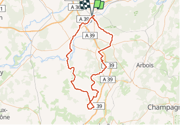
Trail Cycle Dole - Bletterans - Photo
 albert39
albert39

User

© OpenStreetMap contributors
Length
Length
125 km
Max alt
Max alt
254 m
Uphill gradient
Uphill gradient
991 m
Km-Effort
Km-Effort  
138 km
Min alt
Min alt
179 m
Downhill gradient
Downhill gradient
990 m
Boucle
Boucle
Yes
Creation date :
2015-08-31 00:00:00.0
Updated on :
2015-08-31 00:00:00.0

(0 Reviews)

Cycle
Cycle
6h11
Difficulty : Difficult

Scan this QR Code to open this trail in the SityTrail application

FREE GPS app for hiking

Logo SityTrail SityTrail

IGN / Geographical institutes

Download SityTrail from the App Store Download SityTrail from Google Play

Logo SityTrail SityTrail Plus

The world is yours!

Download SityTrail from the App Store Download SityTrail from Google Play Download SityTrail on Huawei AppGallery

About

Trail Cycle of 125 km to be discovered at Bourgogne-Franche-Comté, Jura, Dole. This trail is proposed by albert39.

Description

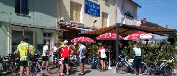
Sortie journée RSGD, organisée par Michel, chaleur et soleil, circuit relax sur la "Bresse". Super repas au resto Le Jura de Bletterans.

Elevation profile

Photos

Points of interest

Point of interest Dole - Point 1 - Photo
albert39
DOLE 
Point of interest Dole - Point 2 - Photo
albert39
DOLE 
Point of interest Ruffey-sur-Seille - Point 3 - Photo
albert39
RUFFEY-SUR-SEILLE 
Point of interest Bletterans - Point 4 - Photo
albert39
BLETTERANS 
Point of interest Bletterans - Point 6 - Photo
albert39
BLETTERANS 
Point of interest Bletterans - Point 7 - Photo
albert39
BLETTERANS 

Positioning

Country:
France
Region :
Bourgogne-Franche-Comté
Department/Province :
Jura
Municipality :
Dole
Location:
Unknown
Start:(UTM)
688432 ; 5218059 (31T) N.


Close
My subscriptions