Trail Walking Dommartin - A_DOMMARTIN 69380 Civrieux - Marand - Photo

A_DOMMARTIN 69380 Civrieux - Marand

 ANDREJAC
ANDREJAC

User

© OpenStreetMap contributors
Length
Length
10.1 km
Max alt
Max alt
308 m
Uphill gradient
Uphill gradient
156 m
Km-Effort
Km-Effort  
12.2 km
Min alt
Min alt
208 m
Downhill gradient
Downhill gradient
156 m
Boucle
Boucle
Yes
Creation date :
2016-10-24 00:00:00.0
Updated on :
2016-10-24 00:00:00.0

(1 Reviews)

Walking
Walking
3h00
Difficulty : Easy

Scan this QR Code to open this trail in the SityTrail application

FREE GPS app for hiking

Logo SityTrail SityTrail

IGN / Geographical institutes

Download SityTrail from the App Store Download SityTrail from Google Play

Logo SityTrail SityTrail World

The world is yours!

Download SityTrail from the App Store Download SityTrail from Google Play Download SityTrail on Huawei AppGallery

About

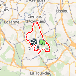
Trail Walking of 10.1 km to be discovered at Auvergne-Rhône-Alpes, Rhône, Dommartin. This trail is proposed by ANDREJAC.

Description

Départ et retour : Mairie de Dommartin.
Montée par Le Falque, parc des sports, La Bergeonnière, descente vers le Besson, Civrieux Marand, remontée vers Le Grand Taillis, La Muselière, retour par la route des bois, rue des Humberts, et la mairie

Elevation profile

Positioning

Country:
France
Region :
Auvergne-Rhône-Alpes
Department/Province :
Rhône
Municipality :
Dommartin
Location:
Unknown
Start:(UTM)
633117 ; 5077063 (31T) N.

Comments

Please log in to post a review or rate the element


ballade géniale, bien arborée et sans trop de profil...à refaire


Trails nearby

Trail Mountain bike Lozanne - La 5ème Vélozannaise (2014-VTT-45km) - Lozanne - Photo
Mountain bike
tracegps

Mountain bike

Difficult
(1)
Lozanne, Auvergne-Rhône-Alpes, Rhône, France
45 km | 59 km-effort
3h 45min
Yes
Trail Walking Lentilly - Santier des vaches LENTILLY  - Photo
Walking
Arthurjcm

Walking

Very easy
(1)
Lentilly, Auvergne-Rhône-Alpes, Rhône, France
3.2 km | 4.1 km-effort
51min
Yes
Trail Running Limonest - Monts d'Or - Limonest - Photo
Running
tracegps

Running

Medium
(2)
Limonest, Auvergne-Rhône-Alpes, Métropole de Lyon, France
21 km | 32 km-effort
2h 0min
Yes
Trail Horseback riding Chasselay - chasselay florian alain  - Photo
Horseback riding
lau74

Horseback riding

Easy
(1)
Chasselay, Auvergne-Rhône-Alpes, Rhône, France
13.3 km | 17.3 km-effort
2h 16min
Yes
Trail On foot Lozanne - De Lozanne à Marcy - Photo
On foot
PRO

On foot

Easy
Lozanne, Auvergne-Rhône-Alpes, Rhône, France
12.2 km | 15.6 km-effort
3h 32min
No
Trail Walking Saint-Jean-des-Vignes - A_ST JEAN DES VIGNES 69380 Pierre Folle - Fontainebleau - Photo
Walking
ANDREJAC

Walking

Easy
(1)
Saint-Jean-des-Vignes, Auvergne-Rhône-Alpes, Rhône, France
8 km | 11 km-effort
3h 0min
Yes
Trail Mountain bike Dardilly - Mont Verdun 2 - Photo
Mountain bike
simon.paume

Mountain bike

Medium
(1)
Dardilly, Auvergne-Rhône-Alpes, Métropole de Lyon, France
17.9 km | 24 km-effort
1h 38min
Yes
Trail Mountain bike La Tour-de-Salvagny - La Tourelloise 2011 30km - Photo
Mountain bike
tracegps

Mountain bike

Difficult
(1)
La Tour-de-Salvagny, Auvergne-Rhône-Alpes, Métropole de Lyon, France
30 km | 42 km-effort
2h 30min
Yes
Trail Walking Limonest - Tour de Limonest - Photo
Walking
tracegps

Walking

Medium
(1)
Limonest, Auvergne-Rhône-Alpes, Métropole de Lyon, France
9.1 km | 13.4 km-effort
2h 15min
No


Close
My subscriptions