Trail Walking Davos - YHH094 Schruns à Tirano (4e jour) - Photo

YHH094 Schruns à Tirano (4e jour)

© OpenStreetMap contributors
Length
Length
19.8 km
Max alt
Max alt
2611 m
Uphill gradient
Uphill gradient
736 m
Km-Effort
Km-Effort  
31 km
Min alt
Min alt
1634 m
Downhill gradient
Downhill gradient
1075 m
Boucle
Boucle
No
Creation date :
2015-09-03 00:00:00.0
Updated on :
2015-09-03 00:00:00.0

(0 Reviews)

Walking
Walking
6h12
Difficulty : Very difficult

Scan this QR Code to open this trail in the SityTrail application

FREE GPS app for hiking

Logo SityTrail SityTrail

IGN / Geographical institutes

Download SityTrail from the App Store Download SityTrail from Google Play

Logo SityTrail SityTrail World

The world is yours!

Download SityTrail from the App Store Download SityTrail from Google Play Download SityTrail on Huawei AppGallery

About

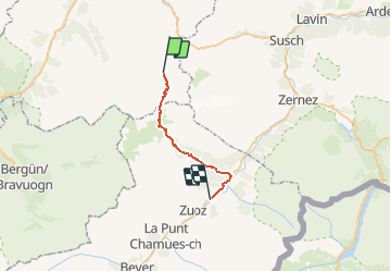
Trail Walking of 19.8 km to be discovered at Grisons, Prättigau/Davos, Davos. This trail is proposed by yveshumbert.

Description

Randonnée de 8 jours au départ de Schruns (Autriche) et arrivée à Tirano (Italie). Etape # 4 Dürboden à S-Champf.
On entame tout de suite la montée au Scaletta pass (90 minutes).
La descente de l autre cote est jolie et facile. Après 3 heures de descente vous arriverez a  Susauna ou il y a la possibilité de se restaurer.
Finalement encore 1h15 pour arriver a S Champf
A S Champs vous pouvez dormir et manger a l hôtel Scaletta. Il y a aussi la possibilité de trouver des chambres ou des dortoirs

Elevation profile

Points of interest

Point of interest S-chanf - Punt da Splii - Photo
yveshumbert
S-CHANF 
Point of interest S-chanf - Susauna - Photo
yveshumbert
S-CHANF 
Point of interest S-chanf - S-Champf - Photo
yveshumbert
S-CHANF 
Point of interest Davos - Durrboden - Photo
yveshumbert
DAVOS 
Point of interest S-chanf - Punt dal Tsachainger - Photo
yveshumbert
Point of interest Davos - Scalettapass - Photo
yveshumbert
Point of interest S-chanf - Alp Funtauna - Photo
yveshumbert
S-CHANF 

Positioning

Country:
Switzerland
Region :
Grisons
Department/Province :
Prättigau/Davos
Municipality :
Davos
Location:
Unknown
Start:(UTM)
570469 ; 5174587 (32T) N.

Trails nearby

Trail On foot Zernez - Flüela-Schwarzhorn - Photo
On foot
PRO

On foot

Easy
Zernez, Grisons, Region Engiadina Bassa/Val Müstair, Switzerland
3.7 km | 11.3 km-effort
2h 34min
No
Trail On foot Zernez - Flüela-Chant Sura - Photo
On foot
PRO

On foot

Easy
Zernez, Grisons, Region Engiadina Bassa/Val Müstair, Switzerland
3.1 km | 4 km-effort
54min
No
Trail Other activity Zernez - y10_davos_schwarzhorn - Photo
Other activity
GUIDE+

Other activity

Very easy
Zernez, Grisons, Region Engiadina Bassa/Val Müstair, Switzerland
3.5 km | 11.2 km-effort
2h 43min
No
Trail Walking Zernez - huetten_01 - Photo
Walking
GUIDE+

Walking

Very easy
Zernez, Grisons, Region Engiadina Bassa/Val Müstair, Switzerland
53 km | 90 km-effort
15h 56min
No
Trail Other activity Zernez - GR / davoser 2. tag - Photo
Other activity
denisewanderige

Other activity

Very easy
Zernez, Grisons, Region Engiadina Bassa/Val Müstair, Switzerland
15.5 km | 27 km-effort
Unknown
No
Trail Other activity Zernez - GR / davoser 1. tag - Photo
Other activity
denisewanderige

Other activity

Very easy
Zernez, Grisons, Region Engiadina Bassa/Val Müstair, Switzerland
9.2 km | 21 km-effort
Unknown
No
Trail Other activity Davos - GR / wägerhus - jörisee - klosters - tag 1 - Photo
Other activity
denisewanderige

Other activity

Very easy
Davos, Grisons, Prättigau/Davos, Switzerland
9.8 km | 18.4 km-effort
Unknown
No


Close
My subscriptions