


tt joakim 22/11/15

olivieraron
User
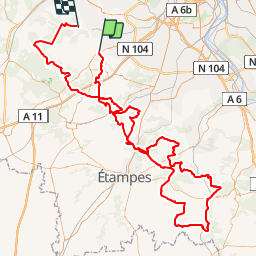

Length
177 km

Max alt
179 m

Uphill gradient
2565 m
Km-Effort
211 km

Min alt
57 m

Downhill gradient
2654 m
Boucle
No
Creation date :
2019-01-14 09:45:04.077
Updated on :
2019-01-14 09:45:04.298
8h20
Difficulty : Unknown

FREE GPS app for hiking
 SityTrail
IGN / Geographical institutes
SityTrail Plus
The world is yours!
About
Trail Other activity of 177 km to be discovered at Ile-de-France, Essonne, Limours. This trail is proposed by olivieraron.
Positioning
Country:
France
Region :
Ile-de-France
Department/Province :
Essonne
Municipality :
Limours
Location:
Unknown
Start:(Dec)
Start:(UTM)
433193 ; 5390249 (31U) N.
Comments