Trail Walking Sierre - Promenade de Finges - Photo

Promenade de Finges

Randonnées de la Maison du tourisme de Crans-Montana GUIDE+

© OpenStreetMap contributors
Length
Length
8.4 km
Max alt
Max alt
633 m
Uphill gradient
Uphill gradient
162 m
Km-Effort
Km-Effort  
10.4 km
Min alt
Min alt
550 m
Downhill gradient
Downhill gradient
89 m
Boucle
Boucle
No
Creation date :
2014-12-10 00:00:00.0
Updated on :
2014-12-10 00:00:00.0

(0 Reviews)

Walking
Walking
2h29
Difficulty : Unknown

Scan this QR Code to open this trail in the SityTrail application

FREE GPS app for hiking

Logo SityTrail SityTrail

IGN / Geographical institutes

Download SityTrail from the App Store Download SityTrail from Google Play

Logo SityTrail SityTrail World

The world is yours!

Download SityTrail from the App Store Download SityTrail from Google Play Download SityTrail on Huawei AppGallery

About

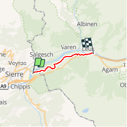
Trail Walking of 8.4 km to be discovered at Valais/Wallis, Sierre, Sierre. This trail is proposed by Maison du Tourisme Crans-Montana.

Elevation profile

Points of interest

Point of interest Sierre - poi_63794 - Photo
Maison du Tourisme Crans-Montana
SIERRE 
Point of interest Leuk - poi_390597 - Photo
Maison du Tourisme Crans-Montana
Point of interest Leuk - Leuk - Photo
Maison du Tourisme Crans-Montana
LEUK 
Point of interest Sierre - Sierre, Camping de Finges - Photo
Maison du Tourisme Crans-Montana
Point of interest Leuk - Leuk, Pfynwald Ermitage - Photo
Maison du Tourisme Crans-Montana
Point of interest Leuk - Pfyn-Finges Naturpark - Photo
Maison du Tourisme Crans-Montana

Positioning

Country:
Switzerland
Region :
Valais/Wallis
Department/Province :
Sierre
Municipality :
Sierre
Location:
Unknown
Start:(UTM)
388960 ; 5127588 (32T) N.

Trails nearby

Trail On foot Anniviers - Chandolin-St Luc - Photo
On foot
PRO

On foot

Easy
Anniviers, Valais/Wallis, Sierre, Switzerland
4.9 km | 7.4 km-effort
1h 40min
No
Trail Walking Sierre - Sierre à Chandolin - Photo
Walking
chandolin

Walking

Very easy
(1)
Sierre, Valais/Wallis, Sierre, Switzerland
11.5 km | 28 km-effort
7h 24min
No
Trail Walking Noble-Contrée - Bisse Neuf and Bisse de Varen - Photo
Walking
GUIDE+

Walking

Very easy
Noble-Contrée, Valais/Wallis, Sierre, Switzerland
10.5 km | 14.8 km-effort
3h 35min
No
Trail Other activity Anniviers - st_bg_ponchet - Photo
Other activity
GUIDE+

Other activity

Very easy
Anniviers, Valais/Wallis, Sierre, Switzerland
8.8 km | 15.9 km-effort
2h 51min
No
Trail Other activity Anniviers - ST_bg_chandolin - Photo
Other activity
GUIDE+

Other activity

Very easy
Anniviers, Valais/Wallis, Sierre, Switzerland
8.9 km | 16.1 km-effort
3h 8min
No
Trail Snowshoes Crans-Montana - L''Aprili - Photo
Snowshoes
GUIDE+

Snowshoes

Very easy
Crans-Montana, Valais/Wallis, Sierre, Switzerland
4.8 km | 9.6 km-effort
1h 37min
No
Trail Mountain bike Crans-Montana - Strecke der Meisterschafs des VTT - Photo
Mountain bike
GUIDE+

Mountain bike

Very easy
Crans-Montana, Valais/Wallis, Sierre, Switzerland
17 km | 29 km-effort
5h 23min
No
Trail Walking Crans-Montana - Aminona-Leukerbad - Photo
Walking
GUIDE+

Walking

Very easy
Crans-Montana, Valais/Wallis, Sierre, Switzerland
17.7 km | 28 km-effort
6h 23min
No
Trail Walking Salgesch - Chemin de la Transhumance - Photo
Walking
GUIDE+

Walking

Very easy
Salgesch, Valais/Wallis, Leuk, Switzerland
20 km | 39 km-effort
9h 19min
No


Close
My subscriptions