


chemin des crêtes

jpipacific
User

Length
11.7 km

Max alt
434 m

Uphill gradient
366 m
Km-Effort
16.6 km

Min alt
266 m

Downhill gradient
367 m
Boucle
Yes
Creation date :
2015-09-07 00:00:00.0
Updated on :
2020-08-26 12:19:25.034
3h52
Difficulty : Medium

FREE GPS app for hiking
 SityTrail
IGN / Geographical institutes
SityTrail Plus
The world is yours!
About
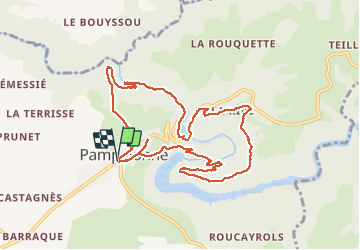
Trail Walking of 11.7 km to be discovered at Occitania, Tarn, Pampelonne. This trail is proposed by jpipacific.
Description
Des montées et des descentes
Photos


Positioning
Country:
France
Region :
Occitania
Department/Province :
Tarn
Municipality :
Pampelonne
Location:
Unknown
Start:(Dec)
Start:(UTM)
439521 ; 4885851 (31T) N.
Comments