


Guerard 2

32mike32
User
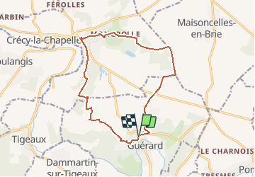

Length
13.9 km

Max alt
150 m

Uphill gradient
253 m
Km-Effort
17.3 km

Min alt
55 m

Downhill gradient
256 m
Boucle
Yes
Creation date :
2015-09-13 00:00:00.0
Updated on :
2015-09-13 00:00:00.0
1h30
Difficulty : Unknown

FREE GPS app for hiking
 SityTrail
IGN / Geographical institutes
SityTrail Plus
The world is yours!
About
Trail Running of 13.9 km to be discovered at Ile-de-France, Seine-et-Marne, Guérard. This trail is proposed by 32mike32.
Positioning
Country:
France
Region :
Ile-de-France
Department/Province :
Seine-et-Marne
Municipality :
Guérard
Location:
Unknown
Start:(Dec)
Start:(UTM)
496702 ; 5408191 (31U) N.
Comments