


mullerthal

semila
User
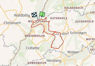

Length
16.1 km

Max alt
385 m

Uphill gradient
384 m
Km-Effort
21 km

Min alt
211 m

Downhill gradient
384 m
Boucle
Yes
Creation date :
2015-09-15 00:00:00.0
Updated on :
2025-08-21 15:22:42.058
4h50
Difficulty : Very difficult
6h34
Difficulty : Unknown

FREE GPS app for hiking
 SityTrail
IGN / Geographical institutes
SityTrail Plus
The world is yours!
About
Trail Walking of 16.1 km to be discovered at Unknown, Canton Echternach, Waldbillig. This trail is proposed by semila.
Positioning
Country:
Luxembourg
Region :
Unknown
Department/Province :
Canton Echternach
Municipality :
Waldbillig
Location:
Unknown
Start:(Dec)
Start:(UTM)
306298 ; 5518866 (32U) N.
Comments