


Lardy et Auvers - 17,2 km

Bastet
User
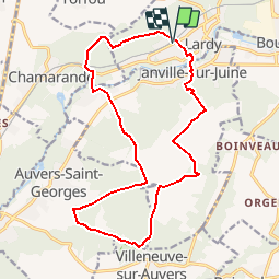

Length
16.9 km

Max alt
162 m

Uphill gradient
316 m
Km-Effort
21 km

Min alt
60 m

Downhill gradient
313 m
Boucle
Yes
Creation date :
2018-05-19 00:00:00.0
Updated on :
2018-05-19 00:00:00.0
1h24
Difficulty : Easy

FREE GPS app for hiking
 SityTrail
IGN / Geographical institutes
SityTrail Plus
The world is yours!
About
Trail Mountain bike of 16.9 km to be discovered at Ile-de-France, Essonne, Lardy. This trail is proposed by Bastet.
Positioning
Country:
France
Region :
Ile-de-France
Department/Province :
Essonne
Municipality :
Lardy
Location:
Unknown
Start:(Dec)
Start:(UTM)
445074 ; 5374445 (31U) N.
Comments