


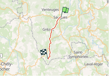
saugues - le sauvage

jib971
User

Length
21 km

Max alt
1332 m

Uphill gradient
617 m
Km-Effort
28 km

Min alt
928 m

Downhill gradient
296 m
Boucle
No
Creation date :
2015-09-20 00:00:00.0
Updated on :
2021-07-25 16:15:45.199
6h53
Difficulty : Easy

FREE GPS app for hiking
 SityTrail
IGN / Geographical institutes
SityTrail Plus
The world is yours!
About
Trail Walking of 21 km to be discovered at Auvergne-Rhône-Alpes, Haute-Loire, Saugues. This trail is proposed by jib971.
Photos


64 photos in total. Please click on a photo to see them all in the gallery.
Positioning
Country:
France
Region :
Auvergne-Rhône-Alpes
Department/Province :
Haute-Loire
Municipality :
Saugues
Location:
Unknown
Start:(Dec)
Start:(UTM)
543215 ; 4978642 (31T) N.
Comments