


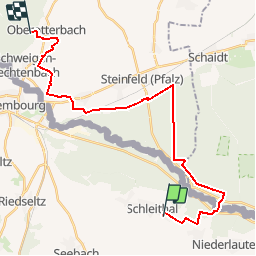
Circuit VDN Schleithal Oberotterbach

Tourisme Equestre Alsace
Promouvoir le Tourisme Equestre en Alsace GUIDE+

Length
25 km

Max alt
225 m

Uphill gradient
289 m
Km-Effort
29 km

Min alt
131 m

Downhill gradient
216 m
Boucle
No
Creation date :
2015-09-24 00:00:00.0
Updated on :
2019-01-05 18:40:15.81
3h41
Difficulty : Medium

FREE GPS app for hiking
 SityTrail
IGN / Geographical institutes
SityTrail Plus
The world is yours!
About
Trail Horseback riding of 25 km to be discovered at Grand Est, Bas-Rhin, Schleithal. This trail is proposed by Tourisme Equestre Alsace.
Photos


Positioning
Country:
France
Region :
Grand Est
Department/Province :
Bas-Rhin
Municipality :
Schleithal
Location:
Unknown
Start:(Dec)
Start:(UTM)
430642 ; 5426362 (32U) N.
Comments