


Chaud Clapier

ajd26
User
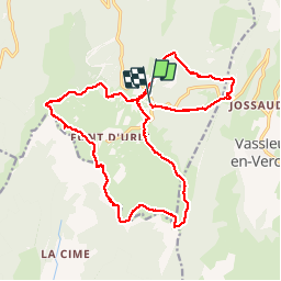

Length
21 km

Max alt
1665 m

Uphill gradient
767 m
Km-Effort
31 km

Min alt
1324 m

Downhill gradient
759 m
Boucle
Yes
Creation date :
2019-05-19 18:04:34.75
Updated on :
2019-05-19 18:04:35.454
5h20
Difficulty : Medium

FREE GPS app for hiking
 SityTrail
IGN / Geographical institutes
SityTrail Plus
The world is yours!
About
Trail Walking of 21 km to be discovered at Auvergne-Rhône-Alpes, Drôme, Bouvante. This trail is proposed by ajd26.
Description
Départ de Chaud Clapier puis Puy de la Gagere et pas de l'Infernet
Photos

Positioning
Country:
France
Region :
Auvergne-Rhône-Alpes
Department/Province :
Drôme
Municipality :
Bouvante
Location:
Unknown
Start:(Dec)
Start:(UTM)
684273 ; 4975413 (31T) N.
Comments