


Renaix - Anvaing

bve9600
User
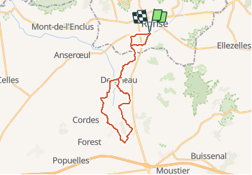

Length
23 km

Max alt
54 m

Uphill gradient
190 m
Km-Effort
25 km

Min alt
18 m

Downhill gradient
190 m
Boucle
Yes
Creation date :
2015-09-27 00:00:00.0
Updated on :
2015-09-27 00:00:00.0
1h00
Difficulty : Unknown

FREE GPS app for hiking
 SityTrail
IGN / Geographical institutes
SityTrail Plus
The world is yours!
About
Trail Other activity of 23 km to be discovered at Flanders, East Flanders, Ronse. This trail is proposed by bve9600.
Description
couper pour un tour plus court Rue de Carnois

Positioning
Country:
Belgium
Region :
Flanders
Department/Province :
East Flanders
Municipality :
Ronse
Location:
Ronse
Start:(Dec)
Start:(UTM)
542154 ; 5621279 (31U) N.
Comments