


avioth

Airelle
User
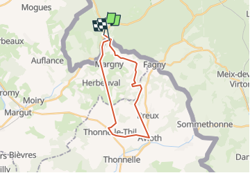

Length
20 km

Max alt
322 m

Uphill gradient
535 m
Km-Effort
28 km

Min alt
193 m

Downhill gradient
523 m
Boucle
No
Creation date :
2015-09-29 00:00:00.0
Updated on :
2015-09-29 00:00:00.0
5h44
Difficulty : Unknown

FREE GPS app for hiking
 SityTrail
IGN / Geographical institutes
SityTrail Plus
The world is yours!
About
Trail Walking of 20 km to be discovered at Wallonia, Luxembourg, Florenville. This trail is proposed by Airelle.
Positioning
Country:
Belgium
Region :
Wallonia
Department/Province :
Luxembourg
Municipality :
Florenville
Location:
Villers-devant-Orval
Start:(Dec)
Start:(UTM)
669358 ; 5500544 (31U) N.
Comments