


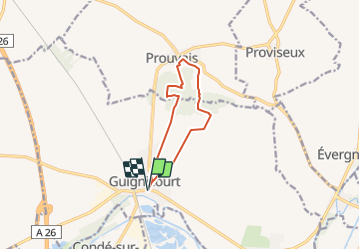
Guignicourt-Prouvais 1

mick211
User

Length
8.7 km

Max alt
171 m

Uphill gradient
162 m
Km-Effort
10.9 km

Min alt
60 m

Downhill gradient
163 m
Boucle
Yes
Creation date :
2015-10-01 00:00:00.0
Updated on :
2015-10-01 00:00:00.0
2h20
Difficulty : Medium

FREE GPS app for hiking
 SityTrail
IGN / Geographical institutes
SityTrail Plus
The world is yours!
About
Trail Walking of 8.7 km to be discovered at Hauts-de-France, Aisne, Villeneuve-sur-Aisne. This trail is proposed by mick211.
Description
Guignicourt - Prouvais AR par le bois le puit et le blockhaus.
Denivelé 160 M
Positioning
Country:
France
Region :
Hauts-de-France
Department/Province :
Aisne
Municipality :
Villeneuve-sur-Aisne
Location:
Unknown
Start:(Dec)
Start:(UTM)
570065 ; 5476196 (31U) N.
Comments