Trail Walking Saint-Cergue - le Noirmont et le Creux du Croue depuis La Cure - Photo

le Noirmont et le Creux du Croue depuis La Cure

© OpenStreetMap contributors
Length
Length
16.2 km
Max alt
Max alt
1557 m
Uphill gradient
Uphill gradient
574 m
Km-Effort
Km-Effort  
24 km
Min alt
Min alt
1164 m
Downhill gradient
Downhill gradient
575 m
Boucle
Boucle
Yes
Creation date :
2015-10-13 00:00:00.0
Updated on :
2015-10-13 00:00:00.0

(1 Reviews)

Walking
Walking
4h18
Difficulty : Medium

Scan this QR Code to open this trail in the SityTrail application

FREE GPS app for hiking

Logo SityTrail SityTrail

IGN / Geographical institutes

Download SityTrail from the App Store Download SityTrail from Google Play

Logo SityTrail SityTrail World

The world is yours!

Download SityTrail from the App Store Download SityTrail from Google Play Download SityTrail on Huawei AppGallery

About

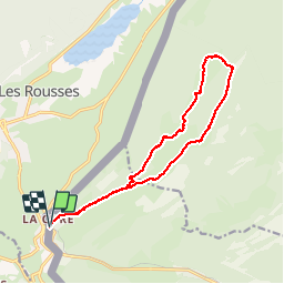
Trail Walking of 16.2 km to be discovered at Vaud, District de Nyon, Saint-Cergue. This trail is proposed by tonymeyer.

Description

Départ de la gare de La Cure.
Prendre la direction de L'Avant Poste et Les Coppettes.
Après 2.5km de montée, prendre le chemin qui part à gauche dans la forêt direction Le Noirmont.
Après 150m, tourner à gauche et plus loin encore à gauche sur la piste, puis après 100m à droite pour monter sur une piste large qui mène au Noirmont (1567m alt.)
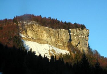
Suivre les balisages jaunes pour descendre dans la combe dans laquelle on reste pour monter jusqu'au bord du Creux.
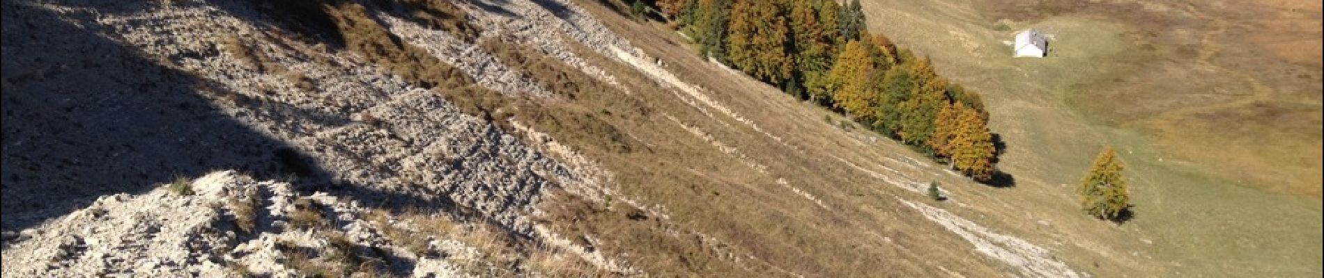
Descendre dans le Creux par un sentier raide puis passer par la bergerie au fond avant de remonter rejoindre le sentier balisé qui part à droite pour Le Croue.
En dessous du Croue (ferme), tourner à droite pour suivre la combe qui monte d'abord puis descend en passant par L'Arzière et Les Coppettes pour revenir à La Cure.

Elevation profile

Photos

Points of interest

Point of interest Arzier - Point 12 - Photo
tonymeyer
ARZIER 
Point of interest Saint-Cergue - Tourner à gauche - Photo
tonymeyer
SAINT-CERGUE 

Positioning

Country:
Switzerland
Region :
Vaud
Department/Province :
District de Nyon
Municipality :
Saint-Cergue
Location:
Unknown
Start:(UTM)
275359 ; 5149678 (32T) N.

Comments

Please log in to post a review or rate the element


Très beau


Trails nearby

Trail Cycle  - Lac de Lamoura et Valserine - Prémanon - Photo
Cycle
tracegps

Cycle

Medium
(1)
, Bourgogne-Franche-Comté, Jura, France
39 km | 49 km-effort
2h 0min
Yes
Trail Walking  - Le Belvédère des Maquisards - Prémanon - Photo
Walking
tracegps

Walking

Medium
(1)
, Bourgogne-Franche-Comté, Jura, France
5.4 km | 7.8 km-effort
2h 0min
Yes
Trail Walking  - Autour de Prémanon - Photo
Walking
tracegps

Walking

Very difficult
(1)
, Bourgogne-Franche-Comté, Jura, France
18 km | 27 km-effort
6h 0min
Yes
Trail Walking Les Rousses - Le Noirmont - Les Rousses - Photo
Walking
tracegps

Walking

Very difficult
(2)
Les Rousses, Bourgogne-Franche-Comté, Jura, France
15.1 km | 23 km-effort
6h 0min
Yes
Trail Walking Prémanon - dole1 - Photo
Walking
fredj

Walking

Very easy
(2)
Prémanon, Bourgogne-Franche-Comté, Jura, France
6.6 km | 12.5 km-effort
1h 49min
Yes
Trail On foot  - Les Arcets - Photo
On foot
PRO

On foot

Easy
, Bourgogne-Franche-Comté, Jura, France
9 km | 13.6 km-effort
3h 5min
Yes
Trail On foot Gingins - La Dôle - Photo
On foot
PRO

On foot

Easy
Gingins, Vaud, District de Nyon, Switzerland
8 km | 15.4 km-effort
3h 30min
Yes
Trail Walking  - Prémanon, Mont Fier  - Photo
Walking
MoiClaude

Walking

Very easy
(1)
, Bourgogne-Franche-Comté, Jura, France
10.9 km | 15.8 km-effort
2h 34min
No
Trail Snowshoes Les Rousses - Lac des Rousses  - Photo
Snowshoes
nfranche

Snowshoes

Medium
(1)
Les Rousses, Bourgogne-Franche-Comté, Jura, France
13.8 km | 18.4 km-effort
4h 15min
Yes


Close
My subscriptions