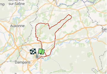
Moissey - Saligney

albert39
User

Length
59 km

Max alt
384 m

Uphill gradient
750 m
Km-Effort
69 km

Min alt
198 m

Downhill gradient
750 m
Boucle
Yes
Creation date :
2015-10-05 00:00:00.0
Updated on :
2015-10-05 00:00:00.0
3h06
Difficulty : Medium

FREE GPS app for hiking
 SityTrail
IGN / Geographical institutes
SityTrail Plus
The world is yours!
About
Trail Cycle of 59 km to be discovered at Bourgogne-Franche-Comté, Jura, Dole. This trail is proposed by albert39.
Description
Quelques bosses dans le Massif de la Serre.
Positioning
Country:
France
Region :
Bourgogne-Franche-Comté
Department/Province :
Jura
Municipality :
Dole
Location:
Unknown
Start:(Dec)
Start:(UTM)
688443 ; 5218070 (31T) N.
Comments