


forêt de camors

rousseau.mich
User
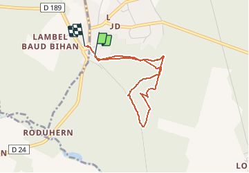

Length
3.3 km

Max alt
122 m

Uphill gradient
47 m
Km-Effort
3.9 km

Min alt
98 m

Downhill gradient
45 m
Boucle
Yes
Creation date :
2015-10-09 00:00:00.0
Updated on :
2015-10-09 00:00:00.0
1h41
Difficulty : Unknown

FREE GPS app for hiking
 SityTrail
IGN / Geographical institutes
SityTrail Plus
The world is yours!
About
Trail Nordic walking of 3.3 km to be discovered at Brittany, Morbihan. This trail is proposed by rousseau.mich.
Positioning
Country:
France
Region :
Brittany
Department/Province :
Morbihan
Municipality :
CAMORS
Location:
Unknown
Start:(Dec)
Start:(UTM)
497450 ; 5297789 (30T) N.
Comments