


131020153

lauramb
User
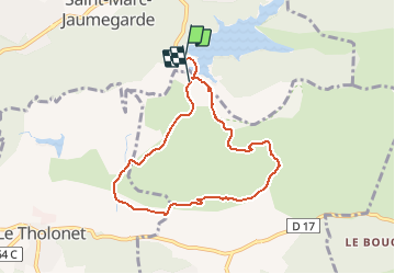

Length
7.4 km

Max alt
384 m

Uphill gradient
240 m
Km-Effort
10.6 km

Min alt
256 m

Downhill gradient
225 m
Boucle
No
Creation date :
2015-10-10 00:00:00.0
Updated on :
2015-10-10 00:00:00.0
2h06
Difficulty : Medium

FREE GPS app for hiking
 SityTrail
IGN / Geographical institutes
SityTrail Plus
The world is yours!
About
Trail Walking of 7.4 km to be discovered at Provence-Alpes-Côte d'Azur, Bouches-du-Rhône, Saint-Marc-Jaumegarde. This trail is proposed by lauramb.
Positioning
Country:
France
Region :
Provence-Alpes-Côte d'Azur
Department/Province :
Bouches-du-Rhône
Municipality :
Saint-Marc-Jaumegarde
Location:
Unknown
Start:(Dec)
Start:(UTM)
704780 ; 4824054 (31T) N.
Comments