Trail Cycle Souspierre - Le Poet Celard - Photo
 Gerbers
Gerbers

User

© OpenStreetMap contributors
Length
Length
66 km
Max alt
Max alt
731 m
Uphill gradient
Uphill gradient
1362 m
Km-Effort
Km-Effort  
84 km
Min alt
Min alt
235 m
Downhill gradient
Downhill gradient
1362 m
Boucle
Boucle
Yes
Creation date :
2015-10-11 00:00:00.0
Updated on :
2015-10-11 00:00:00.0

(0 Reviews)

Cycle
Cycle
4h52
Difficulty : Medium

Scan this QR Code to open this trail in the SityTrail application

FREE GPS app for hiking

Logo SityTrail SityTrail

IGN / Geographical institutes

Download SityTrail from the App Store Download SityTrail from Google Play

Logo SityTrail SityTrail World

The world is yours!

Download SityTrail from the App Store Download SityTrail from Google Play Download SityTrail on Huawei AppGallery

About

Trail Cycle of 66 km to be discovered at Auvergne-Rhône-Alpes, Drôme, Souspierre. This trail is proposed by Gerbers.

Description

info www.revechatoyant.com

D179 Souspierre
D263 Eyzahut
D264
D179
D328 Rochebaudin
D328
D192 Truinas
D233 Pascalin
D328 Le Poet Celard
D328A Dieulefit
D538 Bourdeaux
D191A Orcinas
D191 Orcinas
D191 Comps
D223 Comps


Elevation profile

Positioning

Country:
France
Region :
Auvergne-Rhône-Alpes
Department/Province :
Drôme
Municipality :
Souspierre
Location:
Unknown
Start:(UTM)
655696 ; 4933574 (31T) N.

Trails nearby

Trail On foot Eyzahut - SityTrail - Boucle 1 - Photo
On foot
Julie LABBE

On foot

Very difficult
(2)
Eyzahut, Auvergne-Rhône-Alpes, Drôme, France
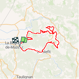
17.3 km | 31 km-effort
6h 0min
Yes
Trail Walking Portes-en-Valdaine - GPX-Rando-Plaine-Portoise-nouvelleversion - Photo
Walking
GUIDE
thonyc

Walking

Easy
(1)
Portes-en-Valdaine, Auvergne-Rhône-Alpes, Drôme, France
7.1 km | 8.2 km-effort
2h 0min
Yes
Trail Walking Portes-en-Valdaine - Portes-en-Valdaine Serre-de-Mirabel 11km. - Photo
Walking
chancha

Walking

Difficult
(1)
Portes-en-Valdaine, Auvergne-Rhône-Alpes, Drôme, France
10.8 km | 14.7 km-effort
3h 20min
Yes
Trail Walking Le Poët-Laval - Le poët laval - Photo
Walking
orlandiniluc

Walking

Medium
(1)
Le Poët-Laval, Auvergne-Rhône-Alpes, Drôme, France
9.8 km | 17.8 km-effort
4h 21min
Yes
Trail Walking Le Poët-Laval - le Poët-Laval et le trou du furet - Photo
Walking
GUIDE
amiral13

Walking

Very easy
Le Poët-Laval, Auvergne-Rhône-Alpes, Drôme, France
7.5 km | 14.3 km-effort
4h 3min
Yes
Trail Walking La Bégude-de-Mazenc - La Bégude de Mazenc - Serre de Forillon - Photo
Walking
tracegps

Walking

Medium
(1)
La Bégude-de-Mazenc, Auvergne-Rhône-Alpes, Drôme, France
8.1 km | 12 km-effort
2h 30min
Yes
Trail Cycle La Bégude-de-Mazenc - La Roche St Secret - Photo
Cycle
tracegps

Cycle

Medium
(1)
La Bégude-de-Mazenc, Auvergne-Rhône-Alpes, Drôme, France
46 km | 56 km-effort
2h 10min
Yes
Trail Walking Le Poët-Laval - Poët-Laval Les vitrouilléres (La Dame Blanche) 9km. - Photo
Walking
chancha

Walking

Medium
Le Poët-Laval, Auvergne-Rhône-Alpes, Drôme, France
8.7 km | 11.5 km-effort
2h 37min
Yes
Trail Walking Le Poët-Laval - Le poet Laval le trou du furet - Photo
Walking
Vero7684

Walking

Medium
Le Poët-Laval, Auvergne-Rhône-Alpes, Drôme, France
10.8 km | 19.4 km-effort
4h 12min
Yes


Close
My subscriptions