


FLAVIGNY 2015-10-12

DENOMME
User
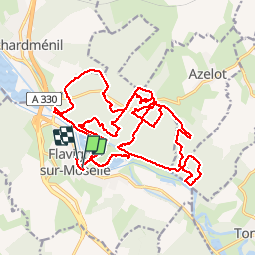

Length
28 km

Max alt
340 m

Uphill gradient
430 m
Km-Effort
34 km

Min alt
222 m

Downhill gradient
431 m
Boucle
No
Creation date :
2015-10-11 00:00:00.0
Updated on :
2015-10-11 00:00:00.0
2h37
Difficulty : Medium

FREE GPS app for hiking
 SityTrail
IGN / Geographical institutes
SityTrail Plus
The world is yours!
About
Trail Mountain bike of 28 km to be discovered at Grand Est, Meurthe-et-Moselle, Flavigny-sur-Moselle. This trail is proposed by DENOMME.
Positioning
Country:
France
Region :
Grand Est
Department/Province :
Meurthe-et-Moselle
Municipality :
Flavigny-sur-Moselle
Location:
Unknown
Start:(Dec)
Start:(UTM)
292693 ; 5383071 (32U) N.
Comments
Appli très utile en rando et peut gourmande en batterie grâce au téléchargement des cartes