


Corconne et la forêt de Coutach

grageot
User
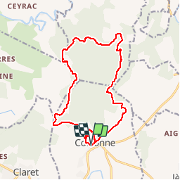

Length
18.1 km

Max alt
407 m

Uphill gradient
547 m
Km-Effort
25 km

Min alt
143 m

Downhill gradient
552 m
Boucle
Yes
Creation date :
2015-10-15 00:00:00.0
Updated on :
2015-10-15 00:00:00.0
5h26
Difficulty : Easy

FREE GPS app for hiking
 SityTrail
IGN / Geographical institutes
SityTrail Plus
The world is yours!
About
Trail Walking of 18.1 km to be discovered at Occitania, Gard, Corconne. This trail is proposed by grageot.
Description
Un départ de corconne ves la chapelle et une ballade sur les sentiers dans la forêt de chênes verts et en bordure de falaise. prendre 30 min pour aller jusqu'au "pont du hasard' une arche naturelle
Positioning
Country:
France
Region :
Occitania
Department/Province :
Gard
Municipality :
Corconne
Location:
Unknown
Start:(Dec)
Start:(UTM)
575360 ; 4858023 (31T) N.
Comments
Merci. Audier
magnifique. beaucoup de coup d'oeil