


mont myon

svp59
User
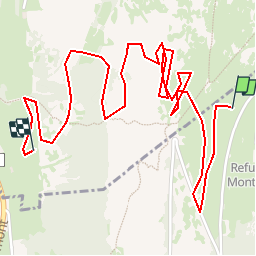

Length
3.4 km

Max alt
623 m

Uphill gradient
39 m
Km-Effort
4.8 km

Min alt
353 m

Downhill gradient
297 m
Boucle
No
Creation date :
2015-10-20 00:00:00.0
Updated on :
2015-10-20 00:00:00.0
46m
Difficulty : Unknown

FREE GPS app for hiking
 SityTrail
IGN / Geographical institutes
SityTrail Plus
The world is yours!
About
Trail Other activity of 3.4 km to be discovered at Auvergne-Rhône-Alpes, Ain, Val-Revermont. This trail is proposed by svp59.
Positioning
Country:
France
Region :
Auvergne-Rhône-Alpes
Department/Province :
Ain
Municipality :
Val-Revermont
Location:
Pressiat
Start:(Dec)
Start:(UTM)
684494 ; 5133554 (31T) N.
Comments