


Etable ardeche

christian4
User
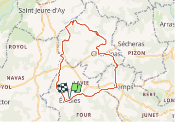

Length
17.3 km

Max alt
531 m

Uphill gradient
375 m
Km-Effort
22 km

Min alt
367 m

Downhill gradient
375 m
Boucle
Yes
Creation date :
2015-10-22 00:00:00.0
Updated on :
2015-10-22 00:00:00.0
4h44
Difficulty : Very easy

FREE GPS app for hiking
 SityTrail
IGN / Geographical institutes
SityTrail Plus
The world is yours!
About
Trail Walking of 17.3 km to be discovered at Auvergne-Rhône-Alpes, Ardèche, Étables. This trail is proposed by christian4.
Positioning
Country:
France
Region :
Auvergne-Rhône-Alpes
Department/Province :
Ardèche
Municipality :
Étables
Location:
Unknown
Start:(Dec)
Start:(UTM)
635814 ; 4995766 (31T) N.
Comments