


M3

brunoperrier
User
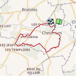

Length
12.5 km

Max alt
121 m

Uphill gradient
129 m
Km-Effort
14.2 km

Min alt
90 m

Downhill gradient
129 m
Boucle
Yes
Creation date :
2015-10-25 00:00:00.0
Updated on :
2015-10-25 00:00:00.0
--
Difficulty : Unknown

FREE GPS app for hiking
 SityTrail
IGN / Geographical institutes
SityTrail Plus
The world is yours!
About
Trail Other activity of 12.5 km to be discovered at Centre-Loire Valley, Loiret, Chevannes. This trail is proposed by brunoperrier.
Description
NOM_BOUCLE = M3<br />NOM_LONG = PR des Deux Rivières<br />


Positioning
Country:
France
Region :
Centre-Loire Valley
Department/Province :
Loiret
Municipality :
Chevannes
Location:
Unknown
Start:(Dec)
Start:(UTM)
489870 ; 5331685 (31U) N.
Comments