


Forêt d'Etréchy - 7,8 km - 2h00

Bastet
User
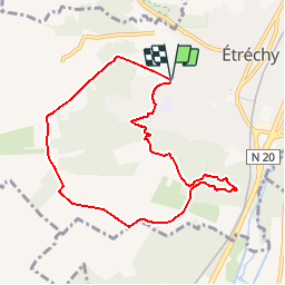

Length
7.9 km

Max alt
146 m

Uphill gradient
130 m
Km-Effort
9.6 km

Min alt
79 m

Downhill gradient
129 m
Boucle
Yes
Creation date :
2018-05-14 00:00:00.0
Updated on :
2018-05-14 00:00:00.0
2h06
Difficulty : Easy

FREE GPS app for hiking
 SityTrail
IGN / Geographical institutes
SityTrail Plus
The world is yours!
About
Trail Walking of 7.9 km to be discovered at Ile-de-France, Essonne, Étréchy. This trail is proposed by Bastet.
Positioning
Country:
France
Region :
Ile-de-France
Department/Province :
Essonne
Municipality :
Étréchy
Location:
Unknown
Start:(Dec)
Start:(UTM)
439314 ; 5371134 (31U) N.
Comments
pas mal de champs mais sympas. la fin était difficile a suivre