


autour de chevigny

daco21
User
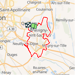

Length
32 km

Max alt
224 m

Uphill gradient
206 m
Km-Effort
34 km

Min alt
203 m

Downhill gradient
204 m
Boucle
No
Creation date :
2019-02-25 13:36:13.699
Updated on :
2019-02-25 13:36:13.731
1h31
Difficulty : Very easy

FREE GPS app for hiking
 SityTrail
IGN / Geographical institutes
SityTrail Plus
The world is yours!
About
Trail Mountain bike of 32 km to be discovered at Bourgogne-Franche-Comté, Côte-d'Or, Chevigny-Saint-Sauveur. This trail is proposed by daco21.
Positioning
Country:
France
Region :
Bourgogne-Franche-Comté
Department/Province :
Côte-d'Or
Municipality :
Chevigny-Saint-Sauveur
Location:
Unknown
Start:(Dec)
Start:(UTM)
660080 ; 5240371 (31T) N.
Comments