


PIC DE NORE

josy31
User
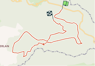

Length
12.8 km

Max alt
1144 m

Uphill gradient
363 m
Km-Effort
17.6 km

Min alt
844 m

Downhill gradient
359 m
Boucle
No
Creation date :
2015-10-30 00:00:00.0
Updated on :
2015-10-30 00:00:00.0
4h27
Difficulty : Unknown

FREE GPS app for hiking
 SityTrail
IGN / Geographical institutes
SityTrail Plus
The world is yours!
About
Trail Walking of 12.8 km to be discovered at Occitania, Tarn, Mazamet. This trail is proposed by josy31.
Positioning
Country:
France
Region :
Occitania
Department/Province :
Tarn
Municipality :
Mazamet
Location:
Unknown
Start:(Dec)
Start:(UTM)
455068 ; 4811428 (31T) N.
Comments