Trail Walking Val de Bagnes - Bagnes, Col des Avouillons - Photo

Bagnes, Col des Avouillons

 rpf
rpf

User

© OpenStreetMap contributors
Length
Length
7.9 km
Max alt
Max alt
2679 m
Uphill gradient
Uphill gradient
682 m
Km-Effort
Km-Effort  
17 km
Min alt
Min alt
2097 m
Downhill gradient
Downhill gradient
682 m
Boucle
Boucle
Yes
Creation date :
2014-12-10 00:00:00.0
Updated on :
2014-12-10 00:00:00.0

(0 Reviews)

Walking
Walking
5h30
Difficulty : Unknown

Scan this QR Code to open this trail in the SityTrail application

FREE GPS app for hiking

Logo SityTrail SityTrail

IGN / Geographical institutes

Download SityTrail from the App Store Download SityTrail from Google Play

Logo SityTrail SityTrail World

The world is yours!

Download SityTrail from the App Store Download SityTrail from Google Play Download SityTrail on Huawei AppGallery

About

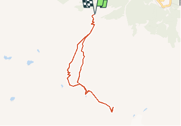
Trail Walking of 7.9 km to be discovered at Valais/Wallis, Entremont, Val de Bagnes. This trail is proposed by rpf.

Description

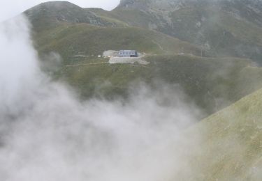
Départ à 2100 mètres à la Cabane Brunet, dans le Val de Bagnes. En été, la Cabane est accessible par une route forestière en excellent état !

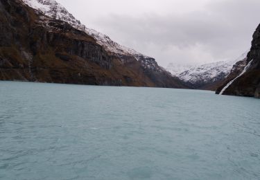
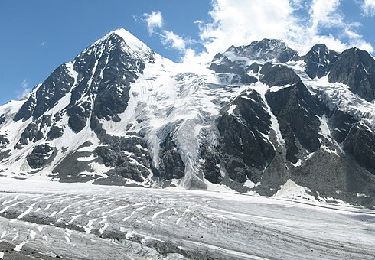
Depuis le Col, extraordinaire vue plongeante sur le Glacier de Corbassière ! La Cabane Panossière (François-Xavier-Bagnoud) est à 50 minutes, de l''autre côté du Glacier.

Une balade de  " www.toprando.ch "

Elevation profile

Positioning

Country:
Switzerland
Region :
Valais/Wallis
Department/Province :
Entremont
Municipality :
Val de Bagnes
Location:
Unknown
Start:(Dec)
Start:(UTM)
366452 ; 5098854 (32T) N.

Trails nearby

Trail On foot Val de Bagnes - Pazagnou-Col des Otanes - Photo
On foot
PRO

On foot

Easy
Val de Bagnes, Valais/Wallis, Entremont, Switzerland
4 km | 11.6 km-effort
2h 38min
No
Trail On foot Val de Bagnes - Fionnay-Bonatchiesse - Photo
On foot
PRO

On foot

Easy
Val de Bagnes, Valais/Wallis, Entremont, Switzerland
4.5 km | 6.3 km-effort
1h 26min
No
Trail On foot Val de Bagnes - Louvie-Fionnay - Photo
On foot
PRO

On foot

Easy
Val de Bagnes, Valais/Wallis, Entremont, Switzerland
3.7 km | 6.3 km-effort
1h 26min
No
Trail On foot Val de Bagnes - Col Termin-Louvie - Photo
On foot
PRO

On foot

Easy
Val de Bagnes, Valais/Wallis, Entremont, Switzerland
3.8 km | 6.3 km-effort
1h 25min
No
Trail Walking Val de Bagnes - Mauvoisin Bonatchiesse - Photo
Walking
michauxpaul

Walking

Difficult
Val de Bagnes, Valais/Wallis, Entremont, Switzerland
8.7 km | 16.2 km-effort
3h 40min
Yes
Trail On foot Val de Bagnes - Promenade de la Dranse - Photo
On foot
PRO

On foot

Easy
Val de Bagnes, Valais/Wallis, Entremont, Switzerland
7.1 km | 9.4 km-effort
2h 8min
No
Trail On foot Val de Bagnes - Chemins pédestres, région Bagnes - Photo
On foot
PRO

On foot

Easy
Val de Bagnes, Valais/Wallis, Entremont, Switzerland
6.2 km | 15 km-effort
3h 24min
No
Trail On foot Val de Bagnes - Bruson - Moay - Photo
On foot
PRO

On foot

Easy
Val de Bagnes, Valais/Wallis, Entremont, Switzerland
3.6 km | 10 km-effort
2h 16min
No
Trail On foot Val de Bagnes - Panossière-La Maye - Photo
On foot
PRO

On foot

Easy
Val de Bagnes, Valais/Wallis, Entremont, Switzerland
3.8 km | 6.4 km-effort
1h 27min
No


Close
My subscriptions