Trail Walking Evolène - Arolla, Cabane des Aiguilles Rouges - Photo

Arolla, Cabane des Aiguilles Rouges

 rpf
rpf

User

© OpenStreetMap contributors
Length
Length
11.8 km
Max alt
Max alt
2832 m
Uphill gradient
Uphill gradient
752 m
Km-Effort
Km-Effort  
22 km
Min alt
Min alt
2080 m
Downhill gradient
Downhill gradient
752 m
Boucle
Boucle
Yes
Creation date :
2014-12-10 00:00:00.0
Updated on :
2014-12-10 00:00:00.0

(1 Reviews)

Walking
Walking
6h30
Difficulty : Unknown

Scan this QR Code to open this trail in the SityTrail application

FREE GPS app for hiking

Logo SityTrail SityTrail

IGN / Geographical institutes

Download SityTrail from the App Store Download SityTrail from Google Play

Logo SityTrail SityTrail World

The world is yours!

Download SityTrail from the App Store Download SityTrail from Google Play Download SityTrail on Huawei AppGallery

About

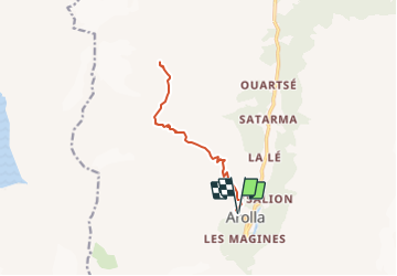
Trail Walking of 11.8 km to be discovered at Valais/Wallis, Hérens, Evolène. This trail is proposed by rpf.

Description

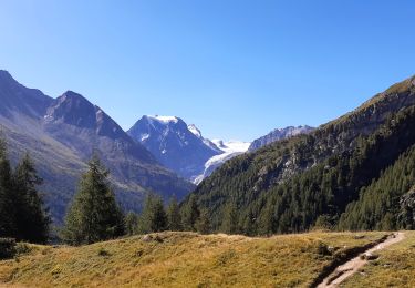
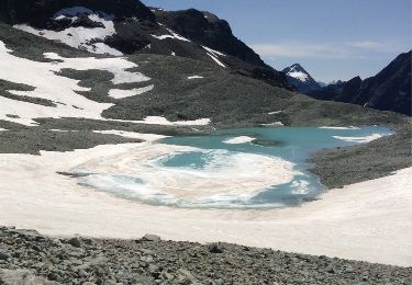
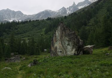
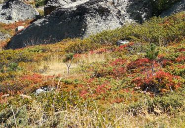
Superbe randonnée aux Aiguilles Rouges d''Arolla !... Belles vues sur le Pigne d''Arolla, splendide, le Mont Collon et le Glacier de Tsijiore Nouve. Et un joli moment au calme près du petit lac juste au-dessus de la cabane. Vraiment un bel endroit !

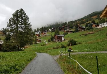
Départ à Arolla, au sommet du village. La route de l''alpage qui mène à Remointse de Pra Gra (2480 m) est interdite à la circulation. Elle peut être fermée par une barrière.
Retour par le même chemin.

Une balade de  " www.toprando.ch "

Elevation profile

Positioning

Country:
Switzerland
Region :
Valais/Wallis
Department/Province :
Hérens
Municipality :
Evolène
Location:
Unknown
Start:(UTM)
382268 ; 5098149 (32T) N.

Comments

Please log in to post a review or rate the element


Trails nearby

Trail Walking Evolène - Arolla – La Sage / Jour 5 - Photo
Walking
Greg813

Walking

Medium
Evolène, Valais/Wallis, Hérens, Switzerland
11.8 km | 19.4 km-effort
3h 18min
No
Trail Walking Evolène - CHX ZRMT Étape 6 d'Arolla à La sage  - Photo
Walking
jeff2

Walking

Easy
Evolène, Valais/Wallis, Hérens, Switzerland
17.3 km | 28 km-effort
5h 34min
No
Trail Winter sports Evolène - Verbier/Zermat (Cabane Bertol-Zermatt) - Photo
Winter sports
GUIDE
lhomme.ph

Winter sports

Very easy
Evolène, Valais/Wallis, Hérens, Switzerland
22 km | 42 km-effort
4h 0min
No
Trail Winter sports Hérémence - Verbier/Zermat (Cabane des Dix-Cabane des Vignettes) - Photo
Winter sports
GUIDE
lhomme.ph

Winter sports

Very easy
Hérémence, Valais/Wallis, Hérens, Switzerland
10.4 km | 26 km-effort
4h 0min
No
Trail Other activity Evolène - col du Collon Tour du Cervin - Photo
Other activity
edes63

Other activity

Very easy
Evolène, Valais/Wallis, Hérens, Switzerland
8.3 km | 18.1 km-effort
4h 39min
No
Trail Walking Evolène - vs_hike674c - Photo
Walking
GUIDE+

Walking

Very easy
Evolène, Valais/Wallis, Hérens, Switzerland
7.5 km | 10.2 km-effort
1h 53min
No
Trail Walking Evolène - st_riedmatten - Photo
Walking
GUIDE+

Walking

Very easy
Evolène, Valais/Wallis, Hérens, Switzerland
16.7 km | 31 km-effort
5h 33min
No
Trail Nordic walking Evolène - arola  - Photo
Nordic walking
suzanne.bron

Nordic walking

Very easy
Evolène, Valais/Wallis, Hérens, Switzerland
10.2 km | 14.8 km-effort
2h 43min
No
Trail Nordic walking Evolène - descente de la cabane du tsa  - Photo
Nordic walking
suzanne.bron

Nordic walking

Very easy
Evolène, Valais/Wallis, Hérens, Switzerland
3.2 km | 5.8 km-effort
1h 14min
No


Close
My subscriptions