Trail Walking Evolène - Evolène, Ruisseaux de Bricola - Photo

Evolène, Ruisseaux de Bricola

 rpf
rpf

User

© OpenStreetMap contributors
Length
Length
6.9 km
Max alt
Max alt
2517 m
Uphill gradient
Uphill gradient
629 m
Km-Effort
Km-Effort  
15.3 km
Min alt
Min alt
1885 m
Downhill gradient
Downhill gradient
632 m
Boucle
Boucle
Yes
Creation date :
2014-12-10 00:00:00.0
Updated on :
2014-12-10 00:00:00.0

(0 Reviews)

Walking
Walking
4h30
Difficulty : Unknown

Scan this QR Code to open this trail in the SityTrail application

FREE GPS app for hiking

Logo SityTrail SityTrail

IGN / Geographical institutes

Download SityTrail from the App Store Download SityTrail from Google Play

Logo SityTrail SityTrail Plus

The world is yours!

Download SityTrail from the App Store Download SityTrail from Google Play Download SityTrail on Huawei AppGallery

About

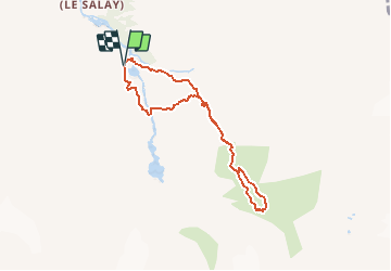
Trail Walking of 6.9 km to be discovered at Valais/Wallis, Hérens, Evolène. This trail is proposed by rpf.

Description

Vers les Glaciers de Ferpècle et du Mont Miné, face au Plateau blanc du Val d''Hérens, sur la corniche qui surplombe la vallée creusée par les géants de glace.

Départ tout au fond du Val de Ferpècle, au petit barrage. La route d''accès est en bon état.

Aucune difficulté pour cette balade, et plusieurs solutions pour la rallonger à souhait, en direction de la Cabane ou du Bivouac de la Dent-Blanche, à condition d''avoir l''expérience et l''équipement voulus pour la glace.

Une balade de  " www.toprando.ch "

Elevation profile

Positioning

Country:
Switzerland
Region :
Valais/Wallis
Department/Province :
Hérens
Municipality :
Evolène
Location:
Unknown
Start:(UTM)
387764 ; 5101562 (32T) N.


Close
My subscriptions