


TRACE GPS PAS DE BOUVARET

TOULAUDIN
User

Length
17.6 km

Max alt
1146 m

Uphill gradient
941 m
Km-Effort
30 km

Min alt
441 m

Downhill gradient
941 m
Boucle
Yes
Creation date :
2015-11-09 00:00:00.0
Updated on :
2015-11-09 00:00:00.0
6h32
Difficulty : Difficult

FREE GPS app for hiking
 SityTrail
IGN / Geographical institutes
SityTrail Plus
The world is yours!
About
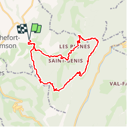
Trail Walking of 17.6 km to be discovered at Auvergne-Rhône-Alpes, Drôme, Rochefort-Samson. This trail is proposed by TOULAUDIN.
Description
TRACE GPS GARMIN ETREX HCX
17.5 KM 1065M
très belle rando ça grimpe dur pour aller au pas de bouvaret
et auusi pour le retour au pas de la pierre attention descente pas de la pierre difficile
Points of interest


Positioning
Country:
France
Region :
Auvergne-Rhône-Alpes
Department/Province :
Drôme
Municipality :
Rochefort-Samson
Location:
Unknown
Start:(Dec)
Start:(UTM)
670933 ; 4982181 (31T) N.
Comments