


CircuitPerso

La Maison du Tourisme de Besançon
Randonnées de la Maison du Tourisme de Besançon
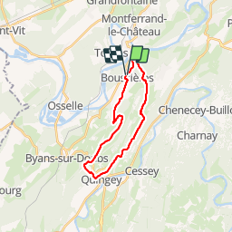

Length
20 km

Max alt
500 m

Uphill gradient
628 m
Km-Effort
29 km

Min alt
235 m

Downhill gradient
627 m
Boucle
Yes
Creation date :
2014-12-10 00:00:00.0
Updated on :
2014-12-10 00:00:00.0
--
Difficulty : Unknown

FREE GPS app for hiking
 SityTrail
IGN / Geographical institutes
SityTrail Plus
The world is yours!
About
Trail Walking of 20 km to be discovered at Bourgogne-Franche-Comté, Doubs, Boussières. This trail is proposed by La Maison du Tourisme de Besançon .
Positioning
Country:
France
Region :
Bourgogne-Franche-Comté
Department/Province :
Doubs
Municipality :
Boussières
Location:
Unknown
Start:(Dec)
Start:(UTM)
720001 ; 5226798 (31T) N.
Comments