


export3

chasle
User
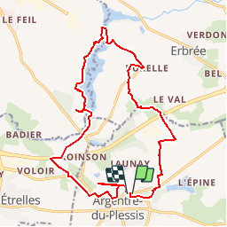

Length
19.1 km

Max alt
122 m

Uphill gradient
233 m
Km-Effort
22 km

Min alt
67 m

Downhill gradient
228 m
Boucle
Yes
Creation date :
2018-02-10 00:00:00.0
Updated on :
2019-03-20 20:22:12.682
4h49
Difficulty : Easy

FREE GPS app for hiking
 SityTrail
IGN / Geographical institutes
SityTrail Plus
The world is yours!
About
Trail Walking of 19.1 km to be discovered at Brittany, Ille-et-Vilaine, Argentré-du-Plessis. This trail is proposed by chasle.
Positioning
Country:
France
Region :
Brittany
Department/Province :
Ille-et-Vilaine
Municipality :
Argentré-du-Plessis
Location:
Unknown
Start:(Dec)
Start:(UTM)
638073 ; 5324775 (30U) N.
Comments