


2015-11-15 sortie club forêt de sénart

Lucquiaud
User
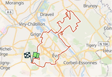

Length
46 km

Max alt
95 m

Uphill gradient
416 m
Km-Effort
52 km

Min alt
25 m

Downhill gradient
416 m
Boucle
Yes
Creation date :
2018-09-15 15:05:52.462
Updated on :
2018-09-15 15:05:52.575
--
Difficulty : Easy

FREE GPS app for hiking
 SityTrail
IGN / Geographical institutes
SityTrail Plus
The world is yours!
About
Trail Mountain bike of 46 km to be discovered at Ile-de-France, Essonne, Bondoufle. This trail is proposed by Lucquiaud.
Positioning
Country:
France
Region :
Ile-de-France
Department/Province :
Essonne
Municipality :
Bondoufle
Location:
Unknown
Start:(Dec)
Start:(UTM)
453896 ; 5384838 (31U) N.
Comments