


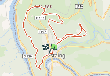
Estaing - 2 collines

jerome1246
User

Length
6.3 km

Max alt
446 m

Uphill gradient
207 m
Km-Effort
9 km

Min alt
322 m

Downhill gradient
207 m
Boucle
Yes
Creation date :
2015-11-18 00:00:00.0
Updated on :
2015-11-18 00:00:00.0
2h03
Difficulty : Medium

FREE GPS app for hiking
 SityTrail
IGN / Geographical institutes
SityTrail Plus
The world is yours!
About
Trail Walking of 6.3 km to be discovered at Occitania, Aveyron, Estaing. This trail is proposed by jerome1246.
Description
Chemin de l''Ouradou puis de la Fage
Positioning
Country:
France
Region :
Occitania
Department/Province :
Aveyron
Municipality :
Estaing
Location:
Unknown
Start:(Dec)
Start:(UTM)
473899 ; 4933466 (31T) N.
Comments