


conflans hautil

olivieraron
User
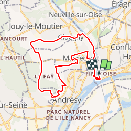

Length
17.3 km

Max alt
173 m

Uphill gradient
257 m
Km-Effort
21 km

Min alt
17 m

Downhill gradient
257 m
Boucle
Yes
Creation date :
2019-01-14 09:44:52.301
Updated on :
2019-01-14 09:44:52.577
8h20
Difficulty : Unknown

FREE GPS app for hiking
 SityTrail
IGN / Geographical institutes
SityTrail Plus
The world is yours!
About
Trail Other activity of 17.3 km to be discovered at Ile-de-France, Yvelines, Conflans-Sainte-Honorine. This trail is proposed by olivieraron.
Positioning
Country:
France
Region :
Ile-de-France
Department/Province :
Yvelines
Municipality :
Conflans-Sainte-Honorine
Location:
Unknown
Start:(Dec)
Start:(UTM)
432295 ; 5426699 (31U) N.
Comments