


Gorges Plérimond par Salernes

soca
User
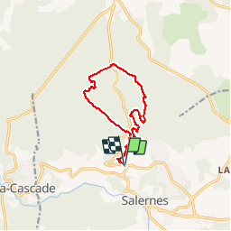

Length
11.8 km

Max alt
484 m

Uphill gradient
332 m
Km-Effort
16.2 km

Min alt
293 m

Downhill gradient
329 m
Boucle
Yes
Creation date :
2015-11-21 00:00:00.0
Updated on :
2015-11-21 00:00:00.0
4h00
Difficulty : Medium

FREE GPS app for hiking
 SityTrail
IGN / Geographical institutes
SityTrail Plus
The world is yours!
About
Trail Walking of 11.8 km to be discovered at Provence-Alpes-Côte d'Azur, Var, Salernes. This trail is proposed by soca.
Positioning
Country:
France
Region :
Provence-Alpes-Côte d'Azur
Department/Province :
Var
Municipality :
Salernes
Location:
Unknown
Start:(Dec)
Start:(UTM)
275911 ; 4828249 (32T) N.
Comments
??? comment on fait pour descendre du point de vue au dessus de la chapelle??????? a part une tyrolienne je ne vois pas comment ,pas de chemin et pour repartir de la station de pompage ,idem