


Sucé rive est de l'Erdre

gmarboeuf
User
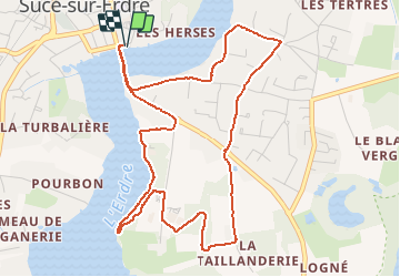

Length
5.6 km

Max alt
26 m

Uphill gradient
71 m
Km-Effort
6.6 km

Min alt
3 m

Downhill gradient
71 m
Boucle
Yes
Creation date :
2015-11-22 00:00:00.0
Updated on :
2015-11-22 00:00:00.0
1h27
Difficulty : Easy

FREE GPS app for hiking
 SityTrail
IGN / Geographical institutes
SityTrail Plus
The world is yours!
About
Trail Walking of 5.6 km to be discovered at Pays de la Loire, Loire-Atlantique, Sucé-sur-Erdre. This trail is proposed by gmarboeuf.
Description
Chemin en partie sur route, au bord de l'Erdre et en campagne
Photos

Positioning
Country:
France
Region :
Pays de la Loire
Department/Province :
Loire-Atlantique
Municipality :
Sucé-sur-Erdre
Location:
Unknown
Start:(Dec)
Start:(UTM)
611403 ; 5243932 (30T) N.
Comments